Hey everybody. Great to be back after a while away from not being able to post. Now that I've gotten a little acclimated to the grad school world at RSMAS, I figured it would be great timing to give a brief overview on Tropical Storm Erika and its potential impacts going through the weekend.
Here is the latest data from the NHC on Erika as of the 8 AM INTERMEDIATE Advisory (5A):
-----ERIKA FOUND TO BE A LITTLE STRONGER...-------
Coordinates: 16.2 N 56.8 W
Max Winds: 40 kts (45 MPH)
Movement: West at 15 kts (17 MPH)
Distance from Miami: ~1635 miles
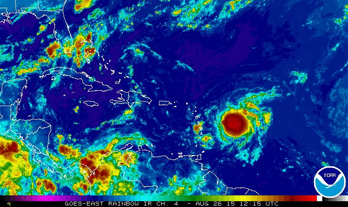
So this morning's Erika looks a little bit more impressive on satellite imagery; convection has regenerated near the center of circulation and there's a neat central dense overcast taking shape. Lack of open areas for dry air entrainment signals a strengthening trend. This strengthening is expected to continue through the rest of the week only if it can keep its rigidity as it enters the waters near the U.S. Virgin Islands and Puerto Rico, as well as avoiding landfall.
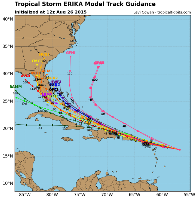
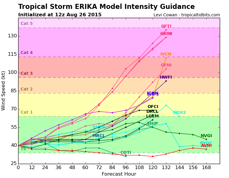
Computer models are still uncertain on the path that Erika will take, but one thing is becoming more certain: A weaker system will retain a west-northwest track through the Bahamas and making a potential landfall somewhere in south Florida this weekend. A stronger Erika will be influenced by the ridge of high pressure to its north and may be recurved into the Atlantic. Intensity also varies with the models... In fact, most landfalling models keep Erika at a category 1 hurricane or a strong tropical storm heading for anywhere between Key Largo to Jupiter. In fact, the TVCN model, which is a general consensus of the AVNI, EGRI, EMXI, NGPI, GHMI, and HWFI computer models, has Erika entering through the upper Keys and curving up through the Gulf of Mexico. Yet there's still some of the Geophysical Fluid Dynamics models (GFNI, GFTI, and GFDI) that have Erika strengthening into a major hurricane and curving before it gets to the southeastern Bahamas.
The point is, IT IS STILL TOO EARLY to determine if we will see anything significant from Erika. Nevertheless, I will say it is not too early to prepare for a potential landfall this Sunday. In no way do I believe this is a Hurricane Andrew or Wilma kind of threat, but this storm bears close watching due to its relatively fixated path on the Bahamas.
I will be updating accordingly tomorrow with more information. Cheers everyone! See below for the images.
Here is the latest data from the NHC on Erika as of the 8 AM INTERMEDIATE Advisory (5A):
-----ERIKA FOUND TO BE A LITTLE STRONGER...-------
Coordinates: 16.2 N 56.8 W
Max Winds: 40 kts (45 MPH)
Movement: West at 15 kts (17 MPH)
Distance from Miami: ~1635 miles
So this morning's Erika looks a little bit more impressive on satellite imagery; convection has regenerated near the center of circulation and there's a neat central dense overcast taking shape. Lack of open areas for dry air entrainment signals a strengthening trend. This strengthening is expected to continue through the rest of the week only if it can keep its rigidity as it enters the waters near the U.S. Virgin Islands and Puerto Rico, as well as avoiding landfall.
Computer models are still uncertain on the path that Erika will take, but one thing is becoming more certain: A weaker system will retain a west-northwest track through the Bahamas and making a potential landfall somewhere in south Florida this weekend. A stronger Erika will be influenced by the ridge of high pressure to its north and may be recurved into the Atlantic. Intensity also varies with the models... In fact, most landfalling models keep Erika at a category 1 hurricane or a strong tropical storm heading for anywhere between Key Largo to Jupiter. In fact, the TVCN model, which is a general consensus of the AVNI, EGRI, EMXI, NGPI, GHMI, and HWFI computer models, has Erika entering through the upper Keys and curving up through the Gulf of Mexico. Yet there's still some of the Geophysical Fluid Dynamics models (GFNI, GFTI, and GFDI) that have Erika strengthening into a major hurricane and curving before it gets to the southeastern Bahamas.
The point is, IT IS STILL TOO EARLY to determine if we will see anything significant from Erika. Nevertheless, I will say it is not too early to prepare for a potential landfall this Sunday. In no way do I believe this is a Hurricane Andrew or Wilma kind of threat, but this storm bears close watching due to its relatively fixated path on the Bahamas.
I will be updating accordingly tomorrow with more information. Cheers everyone! See below for the images.